

OKLAHOMA CITY – The Oklahoma Conservation Commission is nearing the end of this year’s “Blue Thumb” statewide citizen science program.
In Blue Thumb, the commission trains volunteers to monitor creeks and streams and share their knowledge of water quality with others. “The goal is to empower people to protect water in their region from non-point source pollution,” said Bryan Painter, the OCC’s communications director. More than 75 streams in the state are monitored by Blue Thumb volunteers, Painter said.
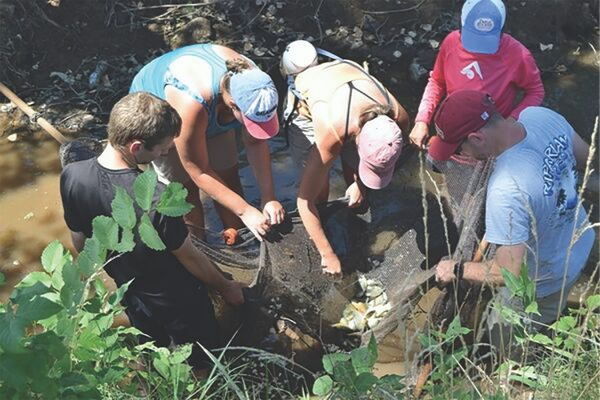
The volunteers identify the physical habitats of the areas they inspect, checking the depths of the waterways, denoting the composition of the bottoms of the creeks, report bank elevations and any erosion, and look for healthy riparian vegetation such as trees, shrubs and grasses that help reduce stream bank erosion. They also seine for fish, most of which are released but a few are taken back to the OCC for Monitoring Specialist Nathan Carter to identify.
“Just as a rule of thumb,” it’s a good sign if the volunteers find five or more different sunfish species (those with sunfish in the name plus bass and crappie), said Kim Shaw, the Blue Thumb quality assurance officer. “That’s because each sunfish species likes to eat something different and like their habitat/home a little bit different,” Ms. Shaw said. This summer, Blue Thumb has fished the Central Great Plains Ecoregion. Five sites in Comanche County were examined this year:
EAST CACHE CREEK OFF SH-7 EAST LAWTON
East Cache Creek (in the vicinity of the Big Green soccer fields off SH-7 on the east side of Lawton).
This site was previously inspected in 2009 and again in 2013. Both assessments “scored well in terms of in-stream cover, pool variability, and streamside cover,” the volunteers reported. Both assessments found “a medium amount of bank vegetation, canopy cover shading, and bank stability.” However, the volunteers reported an increase in silt in the creek bottom, making it “more unstable with the deposition of sediment.” The increased silt and reduction of rocky runs and riffles “reduces the habitat stability for microorganisms and egg-laying fish,” the volunteers pointed out. Also, the water chemistry was “concerning” because of “elevated levels of nutrients...” For instance, phosphorus levels were “very high above-normal conditions.”
EAST CACHE CREEK ROGERS LANE BRIDGE
East Cache Creek (starting at the Rogers Lane bridge and traveling upstream for a quarter-mile). The assessment of this section last occurred in 2013.
At that time the creek scored well “in terms of in-stream cover, flow, and streamside cover.” However, the monitors wrote, “there is not a lot of canopy cover shading over the creek water and there were signs of active bank erosion.” The creek bottom had become more unstable with deposition of sediment, reducing habitat stability for microorganisms and egg-laying fish. Nevertheless, volunteers counted 2,600 fish comprising 22 species, “well above the benchmark average” of 13 species.
However, water chemistry “is a different story; it was very concerning and showed very high and constant levels of nutrients...” Phosphate levels, for example, “were all in the poor zone.”
WEST CACHE CREEK BOULDER PICNIC AREA
West Cache Creek (in the Boulder picnic area). Prior to this summer, this monitoring site was last visited in 2006, during a long-term drought.
“There was plenty of stable instream cover (rocks and woody debris) and the banks are covered with vegetation alternating with bare rock,” volunteers reported.
However, “There is not much canopy cover because the creek is so wide in this reach that though the edges are shaded, the middle of the stream gets direct sun most of the day.” A fish collection conducted in September 2005 yielded 708 fish “but few species: seven,” six of which were sunfish. The creek’s habitat “is excellent,” volunteers wrote. Phosphorous and chloride levels were “very low.” Drought conditions “have had effects on flow and vegetation, but overall the stream appears to be healthy.”
WOLF CREEK NEAR SOCCER PARK
Wolf Creek (in the vicinity of the Louise McMahon Soccer Park on the south side of Lawton).
Bioassays of this area were performed in 2007 and again in 2014. Chemical results did not indicate any threat. The fish and invertebrate community revealed “impairment in-stream water quality.” The stream “letter grade” for fish dropped from a B in 2007 to a D in 2014. The total number of fish species decreased by two-thirds: from 18 different species in 2007 to 6 in 2014. However, the total number of fish collected “almost doubled.”
Over a three-year period (2014, 2015, 2016), the assessment of invertebrate (bugs) activity vacillated from a grade B to an A to a C. “There seems to be a decrease in species richness,” volunteers lamented, and the quality of the stream “has decreased over time.”
WOLF CREEK ON CU CAMPUS
Wolf Creek (on the Cameron University campus just south of Gore Boulevard).
This assessment was performed three years ago, and the volunteers said Wolf Creek “offers a physical habitat quality that is below average for supporting a thriving biological community.” Streamside cover was “the only parameter ... that was determined to have a relatively high rating,” based upon “observations of a large diversity of plant life.” Less than 50% of the stream’s area had “stable, high-quality cover.” The creek had “large areas of silt, sand, and hardpan.” Bank stability received a medium rating because it “shows erosion that reveals numerous tree and bush roots.”
The pool bottom substrate was assessed “to be of low quality,” reflecting a “significant amount of sediment and hardpan. Significantly less than half of the pool bottom was stable substrate to provide habitat.” The fish collection was a bright spot: 1,107 fish were counted, representing 18 species. Macroinvertebrate (insect) collections in 2017 “suggest that the stream quality has drastically improved since 2015” when it was “severely impaired.”
That evaluation was supported “by the emerging populations of pollution-sensitive species.” Chemical data was collected almost monthly between September 2014 and December 2017. Wolf Creek in the vicinity of Cameron was found to have “relatively low” nitrogen and phosphorus pollution and an “average/nor- mal chloride concentration.”
OTHER COMANCHE COUNTY SITES
Other Comanche County sites previously monitored by the Conservation Commission were Post Oak Creek (where Indiahoma Road crosses), Panther Creek (north of Lawton off SH-49), Medicine Creek (approximately 20 miles from its origin as a small spring near Saddle Mountain), and Jimmy Creek (which starts as a natural spring on the Hilliary Ranch and flows south for approximately three-quarters of a mile, where it joins Medicine Creek).
“It takes some time to compile all the data, so it is not immediately available on our website,” Ms. Shaw said. “However, it is entered and over time can be found on the Blue Thumb website.”
LINK TO INTERACTIVE MAP
For a direct link to an interactive map that has the fish lists and volunteer written reports, go to http:// www.bluethumbok.com/ volunteer-written-data-in- terpretations.html. Or for more questions regarding Blue Thumb, contact Bluethumb@Conserva- tion.ok.gov.